
Lake Mashu at dawn – Click to explore much larger image.
Lake Mashu is a caldera from a volcanic eruption 7,000 years ago and is over 200 metres deep. The cliffs surrounding the caldera are 300 to 400 metres high. The Ainu name for the lake, Kamuy-tou, means “Lake of the Gods”. Here it is entirely frozen. Although we arrived before sunrise, there was heavy cloud cover and we didn’t get the intense colour we saw some other mornings. Nonetheless, the setting was so impressive that it really didn’t matter.
The four panoramas in this post will all seem small on this screen. However, they comprise many exposures and the file sizes are huge (up to 2.5GB). They open to images between nine and twenty times larger that you can navigate around inside.
- Click on a panorama and it opens in a new zoomable window.
- In the new window, use the bottom right icon to maximise to full screen.
- Use the [+] and [-] icons or your mouse wheel to zoom in and out.
- Clicking on the image also zooms in; [Home] takes you back to an overall view.
- Hold down your mouse button and move it to move round within the image.

Lake Mashu at Dawn
This is Kamyush Island in the middle of the lake from a different viewpoint to the previous image and taken nearly an hour later. Its name in Ainu means “the old woman who became a god” and it rises 30 metres above the lake.

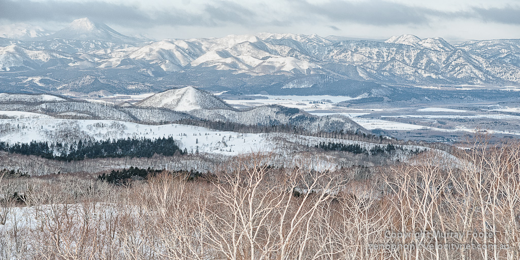
View looking north-west from Lake Mashu caldera rim … – Click to explore much larger image
There was also another grand panorama in the other direction. The next four images also look out in this direction.

…

… Click to explore much larger image …
The distant (extinct or dormant) volcano on the horizon in the image above is possibly Mt Ahorodake, not really sure. Lake Kussharo, where we saw the swans in the previous two days, is behind the mountains in the middle distance.

… Click to explore much larger image …
It looks initially as though it’s a wilderness view. Actually, most landscapes that appear untouched have been affected by Man in some way (probably except Antarctica). In this case, the valley is farmed and if you zoom in and look closely, you can see planted trees, fence-lines, roads and numerous small settlements (presumably farms).
…

…
We stopped here on our way from Lake Mashu (while heading towards breakfast, I should think). There is possibly a very cheap option here for accommodation as a holiday cottage. There appears to be a gas meter on the side of the building, though whether it’s connected may be another matter.
Pingback: Itinerary of Journey to Japan | Murray Foote
These shots are mind-blowing! I especially like your panorama shot. Anyway, how do I get here from Tokyo?
Great post as always!
Thanks very much, Miho.
Lake Mashu is about 50 kilometers north of Kushiro in North-East Hokkaido and a little east. I guess you could drive there though that’s a long way to drive. That leaves plane and train. You could fly or take a train to Kushiro. Then there’s a rail line that goes north and goes through Teshikaga. I presume it stops there, otherwise there’d be a bus. That then leaves you 10 kilometres from Lake Mashu.
Noted. Thank you very much for this!
My pleasure!
Awesome shots! It looks so fabulous! =)
Thank you. Not many places you can get such spectacular and different views in both directions.
Beautiful photography and landscapes!
I have some in my blog also. Hope you like them 🙂
http://damantigui.wordpress.com/2012/05/27/patagonia-photos-enes
Thank you.
I think I commented before. You have some great views of Perito Morino.