Update – Easter Island: A Parable for Our Times?

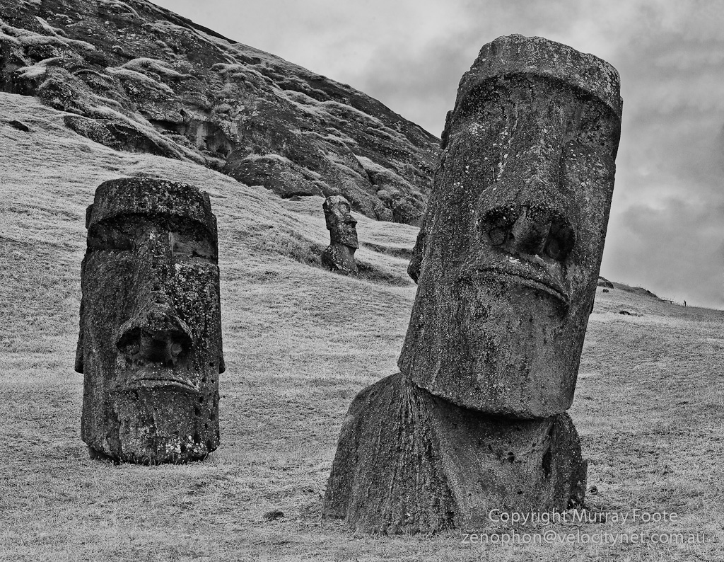
Moai at Ranu Rararaku

Easter Island – A Parable for Our Times? looks at our most important political issue – sustainable development – in the light of what happened on Easter Island.  I have added a brief introduction, seventeen new monochrome images and a  new conclusion.

(It is now a separate post).

Easter Island Wrapup and Contents

It’s now been over two months since I returned from Patagonia, Antarctica, the Falklands, Iguazu Falls and Easter Island.  Most of that time I have been writing up Easter Island, which I have now finished.  Having got home I have been processing all images and therefore posting more of them.

Easter Island especially demands explanations to go with the images and I have given quite detailed accounts of many aspects of the history and archaeology of Easter Island.  There have been 24 posts, 150 images and lots of words.

It started out just about photography.  It’s become somewhat more than that, though the images remain central.

Anakena

One thing I discovered, not in other accounts, was that Easter Island had a two-stage crisis.  First was an ecological crisis that lead to starvation and warfare.  Second and only after European contact, the overthrow of the old religion and the downing of the moai.

I finished up by considering whether the history of Easter Island offers a parable for our times.  I hope many people read this because I believe we all need to understand these issues to help build a consensus for positive change.

Ahu Hanga Kio’e

Below is a list of my special topics.  These are folded into the posts which have quite different names, specific to locations, that may not reflect the content of the special topics.  Further below I also present a list of the titles of the posts and then the sources of my research.

Special Topics

Ahu Te Peu

Posts

Note that posts are not necessarily chonological because they are also combined by content.

Easter Island map – click for larger size (so you can read the place names)

You need to click on the map to get it twice as large so you can read the place names.  The maps covers 16 of the 25 place names in the titles of posts.  Of those not covered:

  • Puna Pau is shown as Maunga Vai Ohao,
  • the South Coast is the whole south-east coast,
  • Ahu Vai Teka is just to the West of Ahu Akivi,
  • Ana Kakenga is just near Motu Tautara (which you can see from the cave),
  • Ahu Hange Kio’e is near Punta Cook,
  • Hanga Taharoa is the bay near Mahatua,
  • Hanga Piko is just below the big point at Hanga Roa,
  • Ana Te Pahu is about halfway between Ahu  Akivi and Ahu Te Peu on the South side of the road
  • and Ahu Runga Vae’e is just below Ahu Hanga Te Tenga.

Ahu Tongariki

Bibliography

My discourse on Easter Island reflects what I’ve read, my observations and my analysis. I don’t claim to be a scientist or an archaeologist.  Apart from being a photographer, I am an economic historian (in terms of academic qualifications) who found a career as a systems developer (and I’m now retired).  Here is a list of the books and articles I used:

Easter Island

– Books

– On the Web

Ahu Hanga Poukura

Ecology

– Books

  • Tim Flannery:  Here on Earth(An Argument for Hope) 2010
    • Confusingly, there seem to be several books with very similar titles.  I suspect that this is publishers’ demand for different markets.  Since this is the Australian version, it is probably the book Flannery intended to write.
  • Tim Flannery:  The Weather Makers (2005)
  • Tim Flannery:  The Future Eaters (1994)
  • Tim Flannery:  The Eternal Frontier (2001)

– On the Web

Ranu Raraku

Easter Island: A Parable for Our Times?

Anakena Moai

On Easter Island, the evidence of human activity from a bygone age is almost everywhere and asks a multitude of questions with a thunderous silence.  It’s almost inescapable to wonder – Does the dramatic decline of Easter Island society speak to us as relevant to the problems of the present?

Easter Island is clearly a small island yet increasingly so is the Earth. Improvements in communication bring us all closer together, we can travel virtually anywhere within a few days, world-wide decentralised mass production makes all economies interrelated and increasingly there are many issues that affect the world as a whole.

To consider this issue we will visit the following topics:

  • Traditional Rapanui society
  • Malthus and the Demographic Transition
  • Our World
      • Deforestation
      • Water
      • Species loss
      • Fishing
      • Overpopulation and resources
      • War
      • Is there a comparison with Easter Island?
      • Global warming and climate change
      • Nuclear power
  • The way forward
  • What Action?

Foundation of a Hare Paenga, a house for the family of a chief, appearing something like an upturned boat

Traditional Rapanui Society

First lets recap from other posts in the blog – what happened to the Rapanui due to the world they had created for themselves?  (I am excluding the direct effects of European disease, predation and colonisation.)

They landed on an island thickly forested with huge trees and populated by probably the largest wild bird colony in the Pacific.  After some centuries they had constructed a remarkable civilisation, a highly organised society with a successful agricultural system,  and undertook remarkable public works that amaze us even today.

Unfortunately, this success came at a cost.  Within a few centuries they had cleared most of the forest for agriculture.  Much of the timber at this stage of abundant resources was probably burnt and wasted.  They still used wood for construction, building canoes, moving moai and for firewood, yet the wood they cut down was slow to regenerate.  Eventually, all the forest was gone apart from some spindly shrubs up to two or three metres in height.  Wild birds and eggs had been a significant part of their diet but they were pretty much either all eaten or their habitat destroyed.  Offshore fishing was no longer possible due to the lack of canoes so dolphin and tuna were no longer available as food.  Clearing the forest had led to erosion which greatly reduced the agricultural capacity and also adversely affected water retention.  As Cook saw, water availability had become a major problem.  The population was greatly increasing at the same time as the resources to support that population were diminishing.

Moai at Ranu Raraku

How had they allowed things to come to this?  I can think of four factors – slowness of change, entrenched interest groups, destructive competition and overpopulation following their period of success.

Life expectancy was probably about 30 years but the trees took much longer than that to regrow.  Drastic change might be obvious if you could see a 500 year period whereas for any 30 year period not much might seem to change.  So if life is “normal” and things seem to be going well, there is much less incentive to become concerned about underlying problems.

The ariki (chiefs) and the ivi atua (priests) led a privileged lifestyle and demanded huge efforts in public works by the ordinary people.  Stopping that system could have stopped their privileged lifestyle.  And the whole massive system of conspicuous consumption in building ever bigger ahu (temples) and moai (statues) was driven by competition between clans and sub-clans.  No point trying to conserve what someone else would just take.

Then when the classical society reached catharsis, prosperity turned to famine and inter-clan competition turned to warfare and even cannibalism.  The population fell by 50% or more even prior to the coming of Europeans.

When Roggeveen arrived in 1722, the classical society, though diminished, was still intact and functioning but when Gonzales turned up in 1770 and Cook in 1774, the priests were no longer visible and many moai had been toppled.  It is therefore likely that the example of the awesomely powerful and wealthy Europeans exploded the power structure and the religion of the classical society and led the Rapanui to overthrow the society themselves.

When Roggeveen’s ship first approached Easter Island, it would have been visible out to sea from here but all the moai were probably standing

Malthus and the Demographic Transition

Malthus wrote in 1798 that all societies were doomed to a perpetual cycle of growth and prosperity alternating with overpopulation and famine.  In this he was opposing the eighteenth century ideal of perpetual progress.  There was no ecological factor to his thinking, so he did not consider that the period of overpopulated desperation might deplete the resource base in ways that would never see recovery.

Our society usually claims to have escaped Malthusian cycles by technological progress.  Developed countries also seem to escape overpopulation through the demographic transition.  Put very quickly, an “underdeveloped” society may have high birth rates and high death rates and exist in a Malthusian equilibrium; a “developed” country may have low birth rates and low death rates and maintain zero population growth; “developing” countries may still have high birth rates but improvements in conditions (health, farming, technology, education) lead to escalating increases in population.  So you’d think the solution would be to get all societies to be “developed”.  Trouble is, that doesn’t take into account resource usage and “developed” countries use disproportionate amounts of scarce and finite resources.

The South Coast (after dark)

Our World

Easter Island is clearly a small island yet increasingly so is the Earth.  Improvements in communication bring us all closer together, we can travel virtually anywhere within a few days, world-wide decentralised mass production makes all economies interrelated and increasingly there are many issues that affect the world as a whole.  So back to the question – Does Easter Island present a parable relevant to the problems of the present?

– Deforestation

The World is not likely to fell all forests quite to the extent of Easter Island.  For example, some countries such as Germany and Japan have had effective forest conservation policies for centuries.  However, worldwide deforestation is a very serious problem.

Japan preserves its own timber but imports timber from other countries.  Australia, for example, sells wood pulp to Japan for making paper.  The prices are very low compared to the price of the paper yet in Australia’s fragile ecosystem, the forests regenerate extremely slowly.  In most cases similar exporting countries are poor and in return wealthy countries are exporting their deforestation problems to poor countries.

The largest remaining forests are in third world countries, especially the tropical rain forests of  the Amazon and Zaire.  About half of the tropical forest that existed in 1800 has already disappeared and at the current rate of destruction, there will be little left outside protected areas by 2050.

Timber may be increasingly in short supply in some countries.  Deforestation can severely degrade cleared land as erosion removes soil, lowers the water table or increases salinity.  The most serious issue, though, is the likely effect of deforestation on World climate.

Overturned ahu and their pukeo (topknots) at Ahu Hanga Te’e O Vaihu

– Water

As Captain Cook saw, availability of drinking water was a serious issue for the Rapanui.  Most people take the supply of water for granted but it is slowly developing into a serious issue, for some countries at least.  Many regions are drawing on underground reserves at an unsustainable rate. This water can be hundreds of thousands of years old and unrestricted drawing up of bore water can also cause problems in soil salinity.

There are also many areas where agriculture depends on spring runoff from glacial melt.  Most glaciers are in rapid retreat and this kind of runoff may reduce substantially.  For example, serious problems for agriculture in Northern India and Bangladesh are likely to develop due to sharply reduced spring water flows resulting from climate change.

– Species loss

The Rapanui managed to wipe out most of their wildlife.  Essentially this was their birds, reduced from a great host to a few seabirds nesting on small offshore islands.  We’re not at a comparable stage of species loss yet, although we’re heading in that direction.  We are in the early stages of a global extinction event and it already has a name – the Holocene extinction.  While this extinction event covers the whole 10,000 years of the Holocene, it mainly relates to the last couple of hundred years and the primary cause is human activity.

Fish petroglyphs

– Fishing

The Rapanui lost access to most of their fish stocks due to lack of wood for canoes which prevented ocean fishing.  Our problem is rather different.  We have no shortage of big metal canoes which bring back huge amounts of fish but we need to be careful we don’t strip the fishing stocks.

It is all too easy to view the oceans as an unlimited resource and awareness of this has improved since the 1970s and 1980s, particularly with the development of maritime reserves and aquaculture (farming of fish and other marine organisms).  The main barrier to sustainability is illegal fishing, which can also devastate areas with illegal trawling methods.

International trade accounts for 38% of fish and fishery products, making it the most traded food in the world.  Over 80% of that trade goes to developed countries, so if other countries continue to become more affluent, it is easy to see there could be greatly increased pressures of demand.

Easter Island’s deep sea fishing stocks and marine diversity were significantly reduced by illegal fishing in just the last few years.  Without appropriate conservation measures, world fishing stocks could be essentially fished out by 2050 (this according to a UN study).

Petroglyphs in a landscape. What may look like vehicle tracks is a canoe carved in the rock.

– Overpopulation and Resources

Sometime after 1400, the Rapanui found themselves in an eroded, treeless land that had a reduced capacity to support them and with a population that had grown to an untenable size.

There can be no question that overpopulation is a serious issue for the world today.   Population growth is most acute for Africa and to a much lesser extent, South America and India.  We cannot isolate ourselves from this; increasingly, like the Easter Islanders, we are living in a small and shrinking island (the Earth).  Just as with Easter Island, it’s not in anyone’s interest for one group to ride roughshod over the rest.  In the words of John Kennedy:  If a free society cannot help the many who are poor, it cannot save the few who are rich.

One thing that can happen is that when a country sees it is over-exploiting its resources, it takes measures to safeguard them but transfers the exploitation to other countries.  This is ultimately self-defeating; when the resources of poorer countries are gone there is nowhere left to turn.

While developed countries often have stable population levels net of migration, they use disproportionately large amounts of resources compared to the world as a whole.  Many of those resources come from less developed countries.  Increasingly there are newly prospering nations that want a share (China, India, South East Asia).   We are already familiar with the essentially fixed supply of petroleum that has already peaked.  It seems likely that resources will not increase to meet demand this time around.

Fortifications inside a lava tube. The piles of rock are about five feet high.

– War

Ecological crisis on Easter Island gave rise to vicious warfare.  The same thing happened to the Southern Maya when their civilisation overran its ecological basis.  Where nations face the exhaustion of resources upon which they depend, such warfare is obviously possible and war in our world can be truly horrific.  We can only hope it doesn’t work out like that.  At least some of the time, we may be able to contribute to public opinion and help prevent inappropriate, hasty or even illegal wars.

Vinapu stonework

– Is there a Comparison with Easter Island?

Deforestation, water availability and species loss are serious problems for us though not often as severe as the outcomes that Easter Island experienced.

The Rapanui experienced a reduced supply of fish due to reduced capability to fish, though their fishing stocks, for deep water fish at least, were not greatly affected.   We run some danger of exhausting world fishing supplies though effective measures may be in place, as long as we can control illegal fishing.

Easter Island experienced severe overpopulation (hand-in-hand with ecological degradation) and their capacity to take effective measures was probably hampered by excessive resource demands of the privileged elite.  Many areas of our world suffer overpopulation, especially Africa, while the developed countries (and even elite groups within developed countries) tie up a high proportion of world resources.

So if that were it, we could say that there are strong parallels with Easter Island and also significant differences.  The world is not as degraded as Easter Island became and we can still address the issues.  In the worst case, we would need to settle for a degraded lifestyle, as did the Rapanui before the arrival of the Europeans.

However, we also have global warming and climate change to contend with and we need to be very sure we understand and deal effectively with those issues as well.

There’s no land out there for thousands of miles….

– Global warming and Climate Change

Sometime between 1400 and 1700, the Rapanui experienced an ecological crisis that resulted in starvation and warfare so that the population fell by 50% to 70%.  After that, they may have reached a period of relative stability.  They still had a viable agriculture although life was much less comfortable and the numbers they could support had fallen.

The issues for the current world that I have summarised above loosely correspond to the crisis that Easter Island went through before European contact.  In the worst case, we will turn many regions arid while many species and  a significant part of humanity will die.  After some time, the chastened humans will regroup and hopefully develop a sustainable way of living under a reduced resource base.

Unfortunately, there is more to it than that.  In the case of the Rapanui, the cataclysm of European contact – disease, exploitation and slavery –almost wiped them out after 1722.  In our case, the somewhat equivalent danger has a quite different cause: global warming and the potential for climate tipping events.

Ahu Te Peu

Some people deny the possibility of global warming when they say “but it’s cold this year, there’s no warming at all”.  This is to misunderstand what it is.  Overall there is warming, the glaciers are melting, the oceans are getting warmer and giving rise to more hurricanes, but it also means greater climatic extremes and in the short-to-medium term, some regions will get warmer and drier while other may get cooler and wetter.  It is true that there can be large natural variations in climate.  It is also true that the great majority of scientists believe that global temperatures have been rising in the last 200 years and that this has a large man-made component.  This view is virtually unanimous for climatologists, those scientists who specialise in climate and climate change.

The most unsettling risk is the possibility of the world ecosystem degrading to fundamentally change the conditions for life.  It has happened before, in previous global extinction events.  It could happen fairly quickly and only be reversible in the very long term, and then to a completely different world, a climate tipping event.

As it stands, if we keep on as we are without effective remedial action, the consequences will be severe.  However, we are not yet at the point of no return.  We can still turn things around.  I think that no-one really knows how much time we have so it is better to act sooner rather than later.  The complication is that there are significant lags involved.  The effective action we take today may take several years to bite.  If necessary, we must be prepared to take one step back to take two steps forward.  If we wait until the situation is catastrophic, it might be too late to recover from.

Te Pito te Kura, Ahu Te Pito Kura

– Nuclear power

In economic terms, we are used to assuming we can always have progress but it’s not necessarily so.  In Europe, for example, Greece’s debt is 150% of its GDP, Ireland’s government deficit is 33% of its GDP, Spain’s unemployment is 20% and Italy owes France $500 billion.   A number of developed countries including the US and Japan appear to have long-term economic problems that will not be easy and quick to address.

We have seen the Japanese experiencing serious problems with explosions in their nuclear reactors, still supposedly under control but unresolved.  Germany and two other European countries have abandoned nuclear power after studying what has happened in Japan.

Indonesia is a much poorer country also prone to earthquakes, volcanic eruptions and tsunamis.  If a situation like Japan’s were to happen in Indonesia, I don’t know what it might develop to if it were to keep on getting out of control.  It couldn’t be good, especially if there were other severe problems to deal with at the same time.  Other countries could at some time descend into economic chaos, civil war or anarchy in such a way as to imperil their reactors.

The economics of wind and solar power keep improving while nuclear power is a short-term solution (plants last for 20 to 50 years) with long-term dangers (waste stays radioactive for hundreds of thousands of years).  Tim Flannery has an interesting view here, though.  He says that notwithstanding the dangers of nuclear power, the dangers of coal power (for global warming) are larger and more immediate.  He also says that wind and solar energy may be cheaper than nuclear by 2018.

Moai at Ranu Raraku

The way forward

We have no way of knowing whether the Rapanui saw their oncoming ecological problems and tried to do something about it while they still had time.  My guess is that they didn’t.  There might have been a groundswell of opinion from the common people for sustainable change but it was probably too unequal a society for that to be possible.

The ariki mau (the divine paramount chief) could have summoned the ivi atua (priests) & the ariki of the clans and compelled them to accept new social & ecological practices to achieve a sustainable society.   Something like this happened in Tokogawa Japan and in quite a different way in the Polynesian island of Tikopia.  My guess is he didn’t, and any attempts were certainly unsuccessful.   The ahu and moai got larger at the end so the Rapanui classical culture probably went out in a spectacular display, trying to persuade the Gods to restore their prosperity. The ariki and the ivi atua were also entrenched interest groups who probably felt threatened by any prospect of change.

Today, progress towards a constructive outcome is impeded by politicians who serve their own interests rather than the common good and by special interest groups who represent ecologically questionable practices.   In both cases, they are arguably not acting even in their own best interests.

We’re not doomed yet although we are clearly facing risks.  I think all of us have a responsibility to Life itself to understand these issues.  Progress will require concerted and enlightened action by government bodies at national and world levels.  It also requires that “we, the people” support appropriate and positive action wherever we can.  Developing a consensus for change is much more productive than competitive argument.

Any risks of moving to a more sustainable society and then finding out it wasn’t as bad as we thought are nothing compared to the risks of doing nothing until it’s too late.

Moai at Huri A Urenga

What Action?

Let’s imagine a world in sustainable balance in fifty or two hundred years – how could we get there?

Developed countries will not be able to wall themselves off from the rest of the world, even if they can attain sustainable development internally.  Therefore, as well as considering the problems of our own countries, we must consider how we can solve ecological problems all around the world.

Action on global warming is under way and if successful it will avert a climate tipping event. In that case, the developed countries will probably achieve some measure of sustainable development sooner or later. The later that is, the more reduced the resource base will be to operate from (and perhaps, the more like Easter Island).

Moai with eyes inserted, at the Tahai Complex

Here are some policy suggestions for a sustainable future:

  • Sustainable Development
      • We need Population Policies at least on a National basis, to determine what populations our environment can support and what infrastructure this requires
          • In the absence of migration, most developed countries would probably already have zero population growth (due to the demographic transition discussed above)
      • We need independent scientific organisations, well-funded and specifically set up to identify what resources we are in danger of exhausting and to recommend policies
          • They should be able to publish reports without political interference and there should be careful measures to ensure scientists do not represent commercial interests where there might be conflict of interest
  • Global Warming
      • We need effective policies to ensure that world climate remains amenable to human life. This has started but there is much to be done. There can be long time lags for measures to bite.
          • Awareness is probably relatively high in Europe, Canada and New Zealand but in the US and Australia there are currently a disturbingly high number of people who think there is no problem and are not prepare to sacrifice a cent for a problem they can’t see.
  • Preserving the Ecology of Poor Countries
      • Developed countries should move towards providing 5% of their gross national income to assist poor countries towards sustainable development
          • In the longer term, this is more important than disaster relief because it will help to prevent disasters. There of course needs to be safeguards against corruption and against siphoning off to first world salaries.
          • The objective of this would be to protect resources, improve living standards and to stabilise populations (eg low family programs, contraception, public awareness campaigns).
          • This may be hard to achieve politically, especially if countries become more and more immersed in their own problems, but if we do not help to solve the ecological problems of poor countries, they will also become ours.

One clear warning Easter Island shows us is that the point of greatest apparent prosperity can also be the point at which the resources that generate that prosperity are exhausted.  Prescience rather than mindless greed is at a premium.

Reality will inevitably be untidy and incomplete.  We have a responsibility to understand as much as we can and support sustainable policies where we can.  We can at least try to be part of the solution rather than part of the problem.

Ahu Tongariki

– Comments welcome

Comments are welcome.  Differing opinions are fine.  Please ensure that comments are polite and reasonable.

(Note:  I have separated out this post from 27th April: Easter Island (Ahu Runga Va’e and Ahu Hanga Te Tenga).  Earlier comments on that post relate to the analysis above).

27th April: Easter Island (Ahu Runga Va’e and Ahu Hanga Te Tenga)

We were due to leave Easter Island for Tahiti around noon but the plane was late, so we got a reprieve for half a day. We headed off towards the Eastern end of the South Coast and visited Ahu Runga Va’e and Ahu Hanga Te Tenga.

This is not the main ahu but a small ahu off to the left on the point at Ahu Runga Va’e

Google map location (green arrow).

Cook’s landing party would have walked past both these ahu on their walk back along the South Coast. They do not mention them although they do mention that another ahu has few moai standing (and this appears to be Akahanga). The moai on these ahu might have been toppled too, but since Cook’s party would have seen the ahu as they walked by, I think it more likely that the moai were still standing and that they considered this unremarkable. (For more on Cook’s visit, see the Hanga Piko post).

Ahu Runga Va’e is about 25 metres above the sea on a peninsula. Surprisingly, a large part of the cliff was artificial, built up from the bottom with large boulders, a stack that has resisted the sea and storms for many hundreds of years.


Coastal view at Ahu Runga Va’e

In the image above, the seaward wall of Ahu Runga Va’e is at the top left (where it’s dark). In the middle distance is a fallen moai. The pale buff rock directly in front is the natural cliff. After that, if you look carefully, you can see the way an artificial cliff is built up with large stones. It’s not obvious from this view but it’s about 80 feet (25 metres) high. You may need to click on the image for a much larger view to see this.


Another view past the side of the main ahu at Ahu Runga Va’e, with the sea and the coast, looking towards Ahu Hanga Te Tenga (which is out of sight)


Fallen moai at Ahu Runga Va’e. You can also see the red cylinder of a pukeo (topknot) in the distance.


View of the coast looking south-east from Ahu Runga Va’e. The headland in the far distance is part of the volcanic cone Rano Kau.

Ahu Hanga Te Tenga is quite large at roughly 80 metres long. It is just 500 metres further on from Ahu Runga Va’e though out of sight behind a headland. The Rapanui attempted to erect the largest moai ever placed on an ahu (at just under ten metres high) but unfortunately it fell over during the erection – so that honour stayed with Moai Paro at Ahu Te Pito Kura.


Ahu Hanga Te Tenga looking south-east-ish along the South Coast.


Ahu Hanga Te Tenga looking north-west-ish along the South Coast. (Click for much larger view).

Click on the image above for a much larger view that you can zoom into and out of. (Then far lower right icon for full screen; and use mouse click, mouse wheel or icons to zoom in and out)

In the image above, the ahu and several moai are at mid-left. Another moai is fenced off further back towards the right. There are ten horses wandering around near that. There are two cars parked nearby. One is our rental car; the white one is from locals who are fishing nearby (an ancient pursuit). You can see them walking to their fishing spot on the rocks below their car. Directly behind the fenced-off moai is the small volcanic cone Maunga Toe Toe. To the left of that is the top of Rano Raraku. Behind that is Maunga Pua Katiki on the Poike Peninsula.

Google maps location (green arrow).


Small ahu on the point at Ahu Runga Va’e

(Note that I have separated out Easter Island – A Parable for Our Times? from this page and the fifteen comments below relate to that post).

27th April: Easter Island (Ahu Huri a Urenga)

Ahu Huri a Urenga is just out the back of town, beside the main road to the other end of the island.  Restored by Mulloy in 1960, it is 13 metres long by 4 metres wide and has been dated to 1215 AD plus or minus 90 years.  The single moai is 3.3 metres tall by 1.45 metres wide and appears to have been recarved because it has four hands rather than two.

Ahu Huri A Urenga. Click on the image to see the extra pair of hands at the right. (The ones at the left are obscured underneath the fungal growth).

Cremation platform behind Ahu Huri A Urenga

Behind the ahu is a cremation platform (as shown at right).  This funereal method became impractical when all the wood was gone.

Many ahus were astronomically aligned and this one is a case in point.  The moai faces the winter solstice sunrise and the ahu has many cupules with solstice and equinox alignments.

There has been some debate as to whether pukeo (topknots) were placed on top of the moai after the moai were erected, or whether the moai and the pukao were strapped together on a frame and raised as one unit.  An unfinished pukao was found at this ahu, which suggests that the pukao were placed on top after the moai were raised.

Speculation:  Did the Spanish get to Easter Island in the sixteenth century?

About twenty years ago, I attended a talk by Canberra author Robert Langdon who suggested that Spanish people made it to Easter island in the early sixteenth century.  He had written several books, travelled to key places and read original documents in sixteenth century Spanish.

Ahu Huri A Urenga

His trail started when he read of the discovery in the 1970s of old Spanish cannons on a reef on an island in the Tuamoto Archipelago.

Following the return of Magellan from his trip around the world, Spain sent another similar expedition that left in 1525 with seven ships under the command of García Jofre de Loaísa.

They had considerable difficulty getting through the Straits of Magellan to the Pacific.  One ship turned around and returned to Spain and two others sunk though their crews were rescued.  Four ships made it through to the Pacific but one, the San Lesmes  separated from the rest in a storm and was never heard of again.

Ahu Huri A Urenga

It seems that after sailing for weeks or months, the San Lesmes ran aground on a reef at Amanu in the Tuamotos.  Getting off the reef required making the ship lighter so they tossed some cannon overboard, just as Cook did on the Great Barrier Reef in Australia on 11 June 1770, some two hundred and forty-four years later.

The cannon recovered from the Amanu reef were later dated to around the 1520s.  It is overwhelmingly probable that they were from the San Lesmes because very few Spanish expeditions traversed the Pacific during the sixteenth century.  This is largely because almost all such expeditions were expensive disasters, yielding little and with very few survivors making it back to Spain.

Langdon claims the ship then went to another island to refit, the crew picked up Polynesian wives and family, and they eventually dispersed to the Society Islands, Easter Island and New Zealand.

When Roggeveen landed on Easter Island in 1722, he made some observations which some might interpret as showing European ancestry.

As for their complexion they are brownish, about the hue of a Spaniard, yet one finds among them some of a darker shade and others quite white, and no less also a few of a reddish tint as if somewhat severely tanned by the sun.

One amongst these (who came on board) was an entirely white man who was wearing chocks of wood in his ears as large as one’s fist and bore a very devout appearance, so we took him to be an idol priest.

… these islanders being in colour between white, swarthy, and reddish, not thick lipped nor flat nosed, the hair chestnut coloured and limp, some have it black, and others tending to a red or cinnamon tint. … their appearance being thoroughly pleasing and tallying with Europeans more than with Indians.

Conversely, Cook saw Polynesians only, generally with black hair.

If the Spanish had made it to Easter Island in the sixteenth century, they wouldn’t have affected the Classic Culture because it was already in decline and seriously short of resources, though they might have contributed to the descent into warfare.

Ahu Huri A Urenga

Katherine Routledge who was in Easter Island in 1914-15, took back to Europe two skulls that she claimed were of quite different types.

However, the Rapanui were particularly enamoured with light coloured skin.  A cave on the Poike Peninsula, Ana O Keke (actually a lava tube and also called Cave of the White Virgin) was said to be used to sequester young women for several months so their skin became very pale and they thereby became specially attractive.  Favoured children might be kept in hare paenga (the boat-shaped houses with no windows) for the same reason.

Similarly, in the Bird Man era, the tangata manu (the Bird Man or Head Chief for a year) was tapu, secluded in a special house and not to be touched.  Something similar may also have applied to the ivi atua (priests) in the classical era, in which case their skin would have been pale for this reason.

It’s an intriguing little loose end to conjure with.  However, it simply may be that Roggeveen’s observations partly reflect the natural variation of Polynesians and partly the workings of Rapanui culture.  Certainly there is no current scientific support that the population of Easter Island was anything than Polynesians.

Some Links to Other Travellers’ Blogs

About five months before this trip, I met David and Denise Hooper at Batman’s Bay Blues Festival, where I was photographer.  David was wearing a Patagonia tee-shirt, I was heading to Patagonia and we got talking.  David gave me valuable information about El Chalten (in Argentina) and Torres Del Paine National Park (in Chile) and the logistics of travelling around by hire car.  This changed and improved our trip.

Earlier, this year, David and Denise went on their own remarkable adventure, to Mali and Ethiopia.  You can see David’s photos and comments in his blog.  Also, you can see a Mali slideshow with an African soundtrack.  Lastly David and Denise remarried in a Tuareg wedding.

View from Maunga Orito, near Ahu Huri Urenga. The slopes of Rano Kau, leading up to Orongo, are at far left. Then there is the runway where we were due to fly out later that day. Directly in front and stretching out to the right is Hanga Roa.

Also, for several days on Easter Island we kept running into someone else with “serious” camera equipment.  They turned out to be an English couple, Michael and Lisa Parker.  You can see photos and comments of his travels in South America and Easter Island in his blog.  This includes some images from inside the Easter Island museum, where I didn’t take photographs, and also some from the Atacama desert, where we didn’t go.


27th April: Easter Island (Ana Te Pahu)

On 27th April we visited Ana Te Pahu, one of Easter Island’s lava tubes, around the middle of the day.  We were also here on the 25th and I was nearby on the 24th.  It is also known as the “Banana Cave”.  Ana means cave and Te is “the” and according to Wikipedia, Pahu is a Polynesian musical instrument, a kind of drum, used in Tahiti amongst other places, so probably the Rapanui name means Cave for playing the drum.

A section where the lava tunnel has collapsed, being very close to the surface here. There are two entrances visible, fortified with stones. This is not the usual entrance to Ana Te Pahu, which is about 500 metres away but it's the same lava tube.. If it's not blocked, you can probably walk through from the right-hand entrance.

Google maps location (then zoom out to find the green arrow and zoom in again).

During the time of warfare after the end of the Classical period, many Rapanui took refuge in lava tubes.  They fortified the entrances and in some cases removed stones from ahus and hare paenga (houses) for this purpose.  The lava tubes were more than temporary places of refuge as demonstrated by items they left behind, including food traces and various implements.  They also had some advantages for cultivating food, including wind protection and better collection and retention of water.

What do we learn from the early accounts of European visitors?

By somewhere between 1400 and 1600, the Rapanui had seriously eroded their ecological base.  Most or all of the wood and birds were gone, as were the larger shellfish.  Dolphin, once a plentiful food source, was no longer available and because there was little wood for canoes, they could also no longer fish for tuna.  There was little firewood and they were reduced to burning grasses, sugarcane detritus and other farming byproducts.  With few clothes, an average minimum of 15ºC in winter would have been chilly (and it might have been a little cooler then, due to the Little Ice Age).

Because resources were not evenly divided amongst the island, some areas would have been affected more than others.  The north-west, in particular, had lost their fishing and had the poorest agricultural land.  Areas around Tongariki and Vinapu still possessed the best rock for carving but this counted for less and less as time went on.  The best agricultural land was in the South and West (though maybe also around Tongariki).  Vinapu and Hanga Poukura, both at the Orongo end of the south coast, had the best three quarries for obsidian, used for sharp blades including spear heads, and this may have become increasingly important.

To the right, a pipi horeko or boundary marker and to the left you can see a cluster of banana trees growing out of an open section of a lava tube.

In the period of the decline of the Classical culture, there was famine and fighting became intense, with much evidence of obsidian spearheads.  There was also a high incidence of charred and fractured human bones, often of juveniles, suggesting likely cannibalism.

It is often suggested that there was a revolution or a coup during this period and that the matato’a or warrior class cast down the ahus and moai and overthrew the ariki and the priests.  This is much too dramatic and simplistic.

Near the main entrance to Ana Te Pahu, the lava tunnel is high and broad and there are stone barriers to make intruders enter one at a time. The photograph doesn't show the scale, but the barriers are about chest high. Defenders had the advantage of being in the dark tunnels, with their eyes already adjusted to low light.

When Roggeveen arrived in 1722, most or all of the ahu and moai were still standing.   Also, the traditional religion appeared to be intact and the ivi atua (priests) were still playing a prominent role.

When Gonzales arrived in 1770, there was still some veneration of the ahus but the Spanish observed no priests.  Women appeared to call out Make Make as the Spanish priests passed them, which may indicate the increasing ascendancy of the new religion of Make Make.  They also observed several people bearing the wounds of obsidian spearheads.  Two small Spanish boats sailed round and mapped the island and they made few comments about moai and ahu, overturned or otherwise.  However, moai were usually overturned forwards onto their faces, away from the sea, and overturned moai may not have been visible from the low viewpoint of a small boat, perhaps often kept some distance off the coast by rough seas.

When Cook arrived in 1774, he reported that there were no signs of veneration of the ahu.  He also reported that a major ahu, probably Akahanga, had most of its moai overturned.  Tongariki and Anakena must have been still standing though there were many places the British did not see.  Cook also gave graphic details of the scarcity of good quality water and how compromised the Rapanui’s consumption of water must have been.  The ground on Easter Island is porous so deforestation and erosion would have made the problems of water supply much worse.  Access to good quality water would also have been unevenly divided amongst the tribes.

Just to the left of the main entrance to Ana Te Pahu, here is a manavai or walled garden, opening to the sky in a natural sink hole.

It appears, therefore, that the overthrowing of the ahus occurred after European contact.  This suggests the following sequence of events:

Fierce competition for diminishing resources led to vicious warfare between the tribes.  The traditional culture still continued.  New ahu were still built for some time, sometimes incorporating old moai.  Then after the Europeans arrived, the Rapanui started toppling their own moai.  Why would that be?

Well, the ariki and ivi atua (chiefs and priests) had a direct line to the Gods or in the case of the ariki mau were actual immortal.  They had a special compact with the people who went to extraordinary lengths to erect statues to the ancestors of individual ariki so that the ariki and ivi atua could intervene with the Gods and guarantee continuing success and prosperity.  But now, the newcomers could strike men down with their fire spears, they came in ships made from unimaginable amount of wood and rope, they had clothes and hats and cloth far finer than paper mulberry bark, and they had lots of red feathers.  (Cook at least knew the value of red feathers for trading in Eastern Polynesia).  How could the ariki and ivi atua still claim to be bringers of prosperity with a direct line to the old Gods?

The manavai we just saw is directly in front of us (behind the wall) and there are banana trees to the right. Greg is on the left, coming out of the entrance to the lava tube, a long single file route going off into the darkness over a rough, rocky floor.

So if we accept that traditional Easter Island society was largely intact when the Europeans arrived, that makes it likely that the example of their fleeting visits tipped it over the edge.  Of course in another sense, Easter Island society had already crashed before Roggeveen arrived and the population had already fallen by 50% or more from the peak of something like 10,000.

Roggeveen estimated the population of the island in 1722 at 3,000 (this from a letter by an Englishman living in Chile who talked to officers of the returning ships, also later reported in an English newspaper).  Gonzalez also estimated the population at 3,000.  (There was another estimate of around 1,000 but I discount that because it does not tally with the 800 who met the ship and the large numbers who met the launch at the other end of the island).  Cook put the population much lower, 600 to 700, two-thirds male.

These estimates are all imprecise.  The population would have been scattered all over the island, we don’t know how many would have been in the lava tubes and that may also have differed between the dates. The visitors all saw most of the island by sea but how much they really saw is hard to say.  Roggeveen only visited on land for a few hours.  Gonzales sent two launches around the island to map it and covered little of the island on foot.  There was a walk from Anakena to Poike to plant flags and an unrecorded diversionary walk to “the West”.  Cook’s party walked around about one quarter of the island only.

Walking into the lava tube, you can walk for quite a while in the darkness, with various twists and turns. Here the lava tube comes out into the sun at a sink hole.

On the face of it, though, the population appears to have declined significantly from the peak of the classical period to 1722.  Then it may have remained roughly steady until 1770, though we know there was warfare in this period.  Perhaps the numbers killed were roughly equivalent to the natural population increase.  Then there might have been a significant reduction, though Cook’s figures still seem too low.  If there were, it may have been as much due to disease as war.

The dismantling of the moai and ahus would still have taken a long time, fifty to one hundred years; there is no reason to assume there was anything sudden about it.  Increasingly, there were many other trials for the Rapanui to contend with. European diseases were not the least of them, culminating in the genocidal raids by the Peruvian slavers in the 1860s.  Remarkably, they survived even that and Easter Island today remains unmistakably Polynesian.

Tree growing up through the sink hole in the lava tube.

Google Maps location (zoom out to find the green arrow, then zoom in; the cave entrance is about 100 metres directly north).

27th April: Easter Island (Hanga Piko)

Before dawn on our last day on Easter Island, we turned up to the island’s tiny port at Hanga Piko (which means place of action).  Here there is a well-restored ahu (Ahu Riata) with a lone eroded moai on top.

This is essentially a man-made port with spare anchorage for the odd small yacht or two and fairly dangerous to come into so it requires a pilot for that.  Until only about fifteen years ago, cargo ships came annually only and supermarket stocks could get quite tight if the ship were delayed.  Now they come more often and they offload their cargo onto small tenders from this small port.

Hanga Piko in the darkness before dawn. There is an ahu and a moai in there, but you can't really see them yet.

There are two tenders that unload freighters, moored under the street lamp at the far left.  In the post of the Tahai Complex, in the images of the boat ramp and the hare paenga, you could see a small ship out to sea which was a freighter offloading supplies.  You probably can’t see the tender alongside the ship in those web images, even if you click to enlarge them, though it is there in the full-sized image.

Early visitors such as Captain Cook did not anchor here, rather off the north-east coast of the island, which is the lee of the island and offers more secure anchorages on sand as well as an easier landing on a sandy beach.

Third Contact: Cook in 1774

Captain James Cook was the third European visitor to the island in 1774, with one ship and 112 men.   They stayed for four days.

“Some hundreds of natives” assembled to watch them land at Anakena.

The country appeared barren and without wood; there were nevertheless, several plantations of potatoes, plantains and sugar canes; we also saw some fowls and found a well of brackish water.

On the second day, Cook sent off a landing party to tour round the island, though since he was recovering from sickness, he felt obliged to remain at Anakena.  The touring party set off at nine in the morning and returned by seven in the evening.  Cook received an account from Lieutenant Pickersgill and Mr Wales.

It's starting to get lighter. A car drives across as a worker arrives for work. A boat under the streetlight at the left has a light on.

Soon after they departed, they were joined by an ariki (chief) who walked along in front of them to guarantee their clear passage.

… a middle aged man, punctured from head to foot, and his face painted by some sort of white pigment, appeared with a spear in his hand, and walked alongside of them, making signs to his countrymen to keep at a distance, and not to molest our people.  When he had pretty well effected this, he hoisted a white piece of cloth on his spear, placed himself at the front, and led the way with his ensign of peace, as they understood it to be.

They took a path that led across to the south-east side of the island and encountered some prime farming land.

Towards the highest part of the south end of the island, the soil, which was a fine red earth, seemed much better, bore a longer grass, and was not covered with stones as it was in other parts; but here they saw neither house nor plantation.

I think this means they have walked to Vaitea, the agricultural heartland of the island, much of which is unfortunately now covered in eucalypt forest (Tasmanian Blue Gum).  The disuse of this land is likely to be a sign of reduced population since the climax of the classical period.

One of the lighters heads out to the freighter (Its navigation light is visible below and to the right of the streetlight at middle left). A few car headlights are visible across the bay.

They came to a place beside the sea on the South Coast where they encountered three platforms of partly or fully overturned moai.

On the east side, near the sea, they met with three platforms of stonework, or rather the ruins of them.   On each had stood four of those large statues; but they were all fallen down from two of them, and also one from the third;  all except one were broken by the fall or in some measure defaced.

There are not many places in this part of the South Coast where there would be three fairly large ahus together.  I think most likely they were at Akahanga. This is the first report of the deliberate destruction of moai on an ahu.

Next they turn around and go back up the coast towards the Poike Peninsula.  The land was barren at first.

From this place they followed the direction of the coast to the north-east, the man with the flag still leading the way.  For about three miles they found the coast very barren, and in some places stript of the soil to the bare rock….

After about three miles, the land became fertile, though good water remained scarce. This would be the area around the small volcanic cone Maunga Toa Toa, which may well have been good farm land.   You may recall that when Roggeveen arrived in 1722, some islanders wanted the Dutch to come over to a part of the island near here where all their food supplies came from.

Beyond this they came to the most fertile part of the island they saw, it being interspersed with plantations of potatoes, sugar canes and plantain trees, and these not so much encumbered by stones as seen before; but they could find no water except what the natives twice or thrice brought them, which, though brackish and stinking, was rendered acceptable by the extremity of their thirst.

It's now past dawn. The other lighter heads off to the freighter which is around the corner to the right. You can now more clearly see Ahu Riata with its lone moai.

Around this time they shot and wounded with buckshot an islander who had stolen the bag of one of the party.  After a period of confusion, their old ariki escort reassured the islanders and led the party further on.  They had no further problems of this kind.

Shortly after this they had a kind of changing of the guard and acquired a new escort.  They appeared to have met the chief of the island, the ariki mau himself.

As they passed along, they observed on a hill a number of people collected together, some of whom had spears in their hands; but, on being called to by their countryman, they dispersed; except a few, among whom was one seemingly of note.  He was a stout, well-made man, with a fine open countenance; his face was painted, his body punctured, and he wore a better Ha Hou or cloth than the rest.  He saluted them as they came up, by stretching out his arms with both hands clenched, lifting them over his head, opening them wide and then letting them gradually fall down to his sides.  To this man, whom they understood to be the chief of the island, their other friend gave his white flag; and he gave it to another, who carried it before them for the remainder of the day.

They found a well with the only good quality water they encountered.  This was towards the eastern end of the island, therefore probably on the Poike Peninsula.  They observed that the islanders compromised the water by bathing in it as well as drinking it.  (This might become an unfortunate practice at times when infectious diseases were endemic.)

They also appear to have arrived at Tongariki and Rano Rarako.

They observed that this side of the island was full of those gigantic statues so often mentioned; some placed in groups on platforms of masonry; others single, fixed only in the earth, and not that deep; and these latter are in general much larger than the others.

They found that all of their party of 30 was able to fit under the shadow of a moai at 2pm.  This was probably one of the moai leaning over in the earth at Rano Raraku which would cast a longer shadow at that time of day than a standing one.

They stopped to eat and climbed a hill where they were able to see both north and east coasts of the island.  I don’t think this hill would be Rano Raraku because they don’t mention the crater lake and they were very interested in water.  Perhaps they had gone back to Maunga Toe Toe or else inland to Maunga Te Olrena.

Here islanders brought them actual salt water to drink which they declined but they report that some islanders drank of this copiously.  This certainly suggests desperation and a critical shortage of water on the part of the islanders.  Consequently, the party returned to the one good well they had found. By this time it was 4pm so they set off overland directly back to the Resolution.

On the way back they found a cache of  several pukao (topknots) in a small hollow in the highest part of the island.  They were larger than previously encountered, in other words, their final carving was yet to come when they reached their intended ahu.  (Mr Wales suggested there was a quarry there, which could not be the case unless they were at Puna Pau, far to the South.   I have considered whether they might have taken an alternative route from Akahanga down the coast to Vinapu instead of up it to Tongariki but this doesn’t seem to fit the descriptions.)

The eroded moai on the well-restored ahu

Cook also related a couple of pages of descriptions of the Rapanui, which I will not say much of here.  His estimate of the population was surprisingly low.

The inhabitants of the island do not seem to exceed six or seven hundred souls; and above two-thirds of those we saw were males.

This is much lower than the figures by Roggevein and Gonzalez (in both cases around 3,000) and it may be understated.  Cook was unable to traverse the island himself, his land party didn’t visit the Western side of the island and much of the population might have been hiding away in lava tubes from the men with spears.

Cook finds a complete absence of the active veneration of the ancient gods that Roogeveen witnessed on the ahus.

The gigantic statues often mentioned are not in my opinion, looked upon as idols by the present inhabitants, whatever they may have been in the days of the Dutch; at least I saw nothing that could induce me to think so.  On the contrary, I rather suppose that they are burying places for certain tribes or families.  I, as well as some others, saw a human skeleton lying on one of these platforms, just covered in stones.

He also reports on significant numbers of pyramidical ahus.

Besides the monuments of antiquity, which were pretty numerous, and nowhere but on or near the sea-coast, there were many little heaps of stones piled up in different places, along the coast.  Two or three uppermost stones in each pile were generally white; perhaps always so, when the pile is complete.  It will hardly be doubted that these piles of stones had a meaning.  Probably they might mark the place where people had been buried, and serve instead of the large statues.

26th April: Easter Island (Hanga Poukura, Vaihu and Akahanga)

Late in the afternoon of the 26th, after we had visited Vinapu, we continued along the south coast to Ahu Hanga PoukuraAhu Hanga Te’e O Vaihu and Ahu Akahanga going half of the way to Tongariki before we ran out of light.  Here are some images and brief comments in the captions.

As well as that, the following text of this post relates the experiences of the second group of Europeans to arrive on the island, Gonzales in 1770, and follows on from the First Contact discussion in the Hanga Taharoa post.

The back of Ahu Hanga Poukura (from the sea) showing one block much more eroded and therefore probably a different type of stone. The ahu is 100 metres long.

Google maps location for Ahu Hanga Poukura (Green arrow).

Second Contact: Gonzalez in 1770

Don Felipe Gonzales arrived at Easter Island in 1770 with up to 736 men and two ships.  Gonzales’ log seems only to contain navigational details but there are two  anonymous accounts, one probably by Don Francisco Antonio de Agüera y Infanzon (Chief Pilot) and another probably by Don Juan Hervé (Pilot).  Gonzalez, incidentally, was 68 when he came to the island, was still sailing ships across the Atlantic at the age of 80 and died aged 90, still in the Spanish Navy.

Sea coast north of Ahu Hanga Poukura

As the ships approached Easter Island, about 12 kilometres south of the Poike Peninsula, Don Francisco Antonio observed many moai, presumably through a telescope.  He talks of many moai inland as well as on the coast.  This might mean that those inland moai were along the whole of the south coast, perhaps along the moai roads, but I suspect it is more likely that he was looking at Ahu Tongariki and the coast to the west of that, so that the inland moai were the moai of Ranu Raraku.

Sea coast looking north from Ahu Hanga Poukura

Gonzalez’ expedition landed at Anakena.  As they rowed to the beach,  “more than 800” Rapanui observed them from the shore.

… There must have been more than 800 people, divided in batches, all wearing cloaks of a yellow colour or white.  There was not the least appearance of hostility, nor of the implements of war about them; I only saw many demonstrations of rejoicing and much yelling.

He also relates later of over 400 Rapanui visitors on board the frigate to the extent that they had to send some away to make way for more.

Remains of small ahu with eroded moai beside the sea at Ahu Hanga Te'e O Vaihu

On shore, Antonio measured one of the moai and commented that there were larger ones on the east coast (such as the one at Ahu Te Pita Kura).  They also found other moai “widely distributed about the countryside in the interior” that were somewhat smaller than those on the beach.  Moai were still objects of worship.

The sculptural forms are called moay by the islanders, who hold them in great veneration, and are displeased when we approach to examine them closely. (Antonio)

They were also shown a human paperbark figure about four metres high, called a kopekaThey further observed numerous pyramidical ahu, burial sites capped with a skull-like white stone.

Paina or ceremonial stone circle in front of Ahu Hanga Te'e O Vaihu

Intra-island warfare had clearly been taking place although, as with the earlier visit by the Dutch, the Rapanui were not hostile and produced no arms.

in some we observed sundry wounds on the body (due to obsidian spear points)

most of the natives on the island dwell in underground caves with narrow and inconvenient entrances, i.e. fortified against attack.

A closer view of Ahu Hanga Te'e O Vaihu with fallen moai and pukao (topknots). The ahu is 100 metres long by 12 metres deep.

The Spanish were on the island for five days and sexual encounters were certainly available.

… the women go to the length of offering with inviting demonstrations all the homage that an impassioned man can desire.

The log doesn’t say this was forbidden and it could be that such encounters occurred.  Since the Dutch were only on shore for a few hours in 1722, this may mark the first point of contact for the Rapanui with infectious European diseases, from the common cold to syphilis.

Eroded carved pukao, Ahu Hanga Te'e O Vaihu. (Some localised flare from raindrops on the lens)

Don Felipe Gonzales sent two launches to row and sail around the island and to map it.   Don Juan Hervé was in one of these launches and provides an account of that voyage.  Also, Don Francisco Antonio provides a short account of a launch voyage, probably of the other launch.

At one place Hervé encountered two small canoes, which he thought may be the only ones on the island.

We saw two little canoes that were coming out … with two men in each.  … These canoes are constructed of five extremely narrow boards (on account of there being no thick timber in the country) about a “quarta” in width (nine inches or 23cm) ; they are consequently so crank that they are provided with an outrigger to prevent them from capsizing; and I think these are the only ones in the whole of the island.

The description of where they saw the canoes (half a league before Cape San Antonio) sounds as though they came out of Ana Kai Tangata, which fits our previous description of the cave:

In the era when wood was scarce, the Rapanui also used the cave as something like a boatshed, a place to build vaka ama, which were small canoes of sewn planks.

At the right end of Ahu Hanga Te'e O Vaihu, this looks to me very much like a mooring for a boat, with what could be a groove worn by mooring rope in the rocks below to the red scoria hook. Of course, this could be a relatively recent use of a fragment of an old pukao.

Hervé’s launch stayed overnight at a small cove which by the description appears to be near Vinapu, where today a small road comes down to the sea below the oil refinery.   They report a cave with furrows “of various tints” where the Rapanui obtained their pigments.  The men had been warned not to harass the Rapanui and on a walk of about nine kilometres, saw abundant cultivations.

… we stood in towards a smooth patch of foreshore about a league away to the N.E. of Cape San Francisco. (i.e. 4.2 kilometres from Orongo).  Here we decided to bring up the night….

The officer, Don Cayetano de Langara, issued orders to our people that no one, under pain of a severe flogging, should accept any article from the islanders without giving something equivalent in return, or something of greater value than that which they received, since it was known there was a disposition to exchange articles; and such in fact was put in practice.

We walked about two leagues, (9 kilometres) and at that distance (throughout which many islanders accompanied us) we saw a plantain garden which stretched about a quarter of a league in extent, and was about half that distance in breadth. (equivalent to 1 x 0.5 kilometres).  There were other small plantain gardens and several plantations and fields of sugar-cane, sweet potatoes, taro, yams, white gourds, and plants like those whose leaves are employed at the Callao for making mats. (Hervé)

By contrast, Antonio’s account suggests less abundant cultivation.  This probably indicates the other launch visited other locations that may either have been less suited to agriculture or else were affected by warfare or hardship.

The fields are uncultivated save some small polts of ground, in which they sow beds of yuca, yams, sweet potatoes and several plantations of plantains and sugar cane…

Antonio also makes the unsurprising observation that wood was scarce.

… throughout the island not a single tree is to be found capable of furnishing a plank so much as six inches in width…

Sea coast near Ahu Hanga Te'e O Vaihu

Antonio also describes the dwelling of an ariki (chief) which is the hare paenga as described earlier (eg Tahai Complex) and also the dwelling of an Ivi Atua (priest) located close to the ahu.

Others (whom I believe to be their ministers) occupy dwellings close to the statues; these are built of earth below, but with an entrance way or porch of very roughly hewn and clumsily set up stones, after the fashion of a wall, with a certain number of steps for passing from one platform or surface of ground to another on different levels.

Remains of large hare paenga at Ahu Akahanga. There are the remains of a large village here.

On returning to the ship, Hervé compiled the following map from their measurements (click for larger size):

1770 Map of the Island, South at the Top (from Wikipedia)

On the last day, a party journeyed from Anakena to erect three wooden crosses on the three small cones on the Poike Peninsula, a distance of about 10 kilometres.  This journey is what the lower part of the map above represents, from right to left on that map (and roughly ESE in direction).  The map shows moai (presumably representing intact ahu) near Ahu Hekii, Ahu Rai’i and Ahu Mahatua (the last being an ahu in Hanga Taharoa).

At the same time, a diversionary party of 230 men also went ashore proceeding to the West side of the island.  This was so that huge crowds of onlookers would not impede erecting the crosses.

The Rapanui seem to have been suitably impressed by the religious rituals of the two Spanish priests who accompanied the crosses.  Antonio reports that the women cried out Maca Maca as the priests walked past, incanting.  I presume their call was actually Make Make (perhaps in the sense of “Praise be to God”) and this could be a marker of the gradual replacement of the traditional religion with the newer one of Make Make.

They seem to me to have ministers or priests for their idols; because I observed that on the day which we erected the crosses, when our chaplains went accompanying the holy images, clothed in their cassocks and “pelliz”, chanting the litanies, numbers of natives stepped forward on the paths and offered their cloaks, while the women presented hens and pullets and all cried “Maca Maca”, treating them with much veneration until they had passed beyond the rocks by which the track they were following was encumbered.

When the Spanish had planted the crosses, they conducted a ceremony whereby Spain claimed the island.  They obtained “signatures” of available Rapanui, presumably to demonstrate their acquiescence, though the Rapanui can have had no idea what they were affixing their marks to.

A large moai toppled on the ahu at Akahanga. It's still in one piece. Setting sun in the background. (Sorry but the image is out of focus, no point zooming in).

26th April: Easter Island (Vinapu)

At mid-afternoon on the 26th we went to Ahu Vinapu O Tahiri, which is famous for its fine stone work, as you can see here.  (You can also click the image above for a much larger view.)

Alternatively, here is a detail.

This is probably the head re-erected by Thomson in 1889.

Here is another part of the ahu wall, which is 80 metres long by 12 metres wide.  People often wonder “How did they cut those stones?”.  Carving the moai from volcanic tuff using granite tools is one thing but ahu facing walls were often granite.  Perhaps the simple answer is they didn’t carve them, for the final fit at least.


My guess is that they put one stone on top of another (easy to say), perhaps with a wooden frame around the top one, and hauled on ropes to move the top stone back and forth and slowly grind the edges to match.  That way, there’s also no requirement for right angles.

Vinapu was cited in the past (for example by Heyerdahl) as evidence of Inca influence but the current consensus of archaeologists is to discount that.  For one thing, the technique is different.  Whereas the Incas used solid stone blocks, these are facing blocks for rubble fill.  You can see this from the side view, here.

Also, the average weight of the blocks here is about 7 tonnes and the largest 10 or 12 tonnes; the largest blocks in the Inca Sacsayhuamán fortress weighted somewhere between 120 and 360 tonnes!

Stepping back a bit, here is a side view of the ahu with toppled moai.   (You can also see in the distance the carpark and also the refinery poking its ugly head up between the moai and the ahu.)

Curiously, there is a dwelling space at the front of the ahu,  created after the fall of the moai, using the fallen moai itself as part of the roof.

There are actually two ahus at Vinapu. We have been looking at Vinapu I which paradoxically is the later of the two.  The image above and the next one is from Vinapu II, which has been dated as far back as 900AD.

The reason the numbering of the ahus is the wrong way round is because Thor Heyerdahl thought that the one with the finer stonework was made by South Americans prior to the arrival of Polynesians on the island but this has been refuted by carbon dating of charcoal buried under or around the ahus.

The ring of stones around the moai head in the foreground is not ancient; it is just to keep people back.

In the distance we can see the fallen moai on Ahu Vinapu II and over to the right a pukao or topknot.

In the front is a most unusual moai.  It is made of the soft red scoria, like the pukao, and is now greatly eroded.  Fortunately there is a description from the early nineteenth century when its form was still visible.  It was a female moai, with a vulva visible near the ground and lacking the usual male loincloth.  It also had two heads and had a special use for funerary functions.

They would wrap one or more dead bodies in bark cloth and suspend them on poles that rested between the two moai heads until the flesh rotted away.  Then the bones were washed and deposited inside the ahu.

The Rapanui also used cremation, uniquely for Polynesia.  There are, for example, cremating platforms behind Ahu Akivi and Huri A Urenga. The burial practices associated with this moai may therefore have been a later practice, after the supply of wood ran out.

Google Maps location (green arrow).

22nd April: Easter Island (Hanga Taharoa)

Hanga Taharoa (or Taharoa Bay, if you like) is on the north coast of Easter island, about four kilometres east of Ahu Te Pito Kura and about four kilometres over the peninsula from Tongariki.  In 1722 Roggeveen landed somewhere along this coast, which could have been at Hanga Taharoa or else a bit further west, at or near Ahu Te Pito Kura.

Two birds on fence-posts in front of a hare moa (chicken house) or tupa (tomb). The birds are Chimango Caracara, introduced from South America. There are no native land birds remaining on Easter Island (unless you count the moa or chicken). We are at Hanga Taharoa, about 80 metres back from the shoreline.

First Contact:  Roggeveen in 1722

The first European visitor to Easter Island was the Dutch Roggeveen in 1722, who arrived with three ships and 223 men.  There are two accounts of the landing, one by Roggeveen and another by Behrens.

This was not without incident.  Many Rapanui swam out to the ships or came by canoe and one was shot “by some misadventure”.  The Dutch landed with 143 men and “10 to 12” Rapanui were shot dead and others wounded when “they tried to lay hold of our weapons”.

The remains of an ahu that would have been part of the Hanga Taharoa village, about 100 metres back from the shoreline.

The Rapanui, though, were neither armed nor hostile and after the Dutch had assured them they had no desire to use their weapons, they continued to a remarkably exuberant welcome given the earlier incidents:

They kept up an uncommon yelling: women as well as children brought palm branches, red and white streamers, and various kinds of fruits, indian figs, large nuts, sugar-cane, roots, fowls, – alive, boiled and roast.  They even flung themselves at our feet, displayed the streamers in front of us, and prostrated the streamers on the ground in front of us, presenting their palm branches as peace offerings.  They also made tender of the womankind, asking whether we would accompany them into the huts, or had rather take them off to the ships.  However, we did them no ill, … and they gave 50 or 60 ells of brightly coloured cloth (probably 50 or 60 metres), coral baubles and mirrors and received large quantities of live fowl, sweet potatoes and other foods in return. (Behrens)

Most or all of the moai appear to be standing at this point.  The accounts are brief but do not include any mention of toppled moai.  There might have been some toppled in other areas because they probably wouldn’t see toppled moai from the ship and they were only ashore for a couple of hours.

We could see great numbers of heathen idols erected on shore.

Sunlight through the clouds, looking probably a bit North of West from Hanga Taharoa

Whatever had happened since the wood ran out, the traditional religion appears fully functional and there are several accounts of worship at the ahu by the people as well as of the appearance and behaviour or the priests.

In the early morning we looked out and could see from some distance that they had prostrated themselves towards the morning sun and had kindled some hundreds of fires, which probably betokened a morning oblation to their gods. (Behrens)

What form the worship of these people comprises we were unable to gather any full knowledge of, owing to the shortness of our stay amongst them; we noticed only that they kindle fire in front of certain remarkably tall stone figures they set up; and, thereafter squatting on their heels with heads bowed down, they bring the palms of their hands together and alternately raise and lower them. (Roggeveen)

… they relied in case of need on their idols which stand all along the sea shore in great numbers, before which they fall down and invoke them.  … I took some of the people to be priests, because they paid more reverence to the gods than did the rest; and they showed themselves much more devout in their ministrations.  One could distinguish these from the other people quite well, not only by their wearing great white plugs in their ear lobes, but in having the head wholly shaven and hairless. … They wore a headdress of black and white feather that were just like stork’s feathers…. (Behrens)

I have read about pyramidical ahus and presume this is one. They are a later development and would also be a grave for one or more persons. At Hanga Taharoa.

The place where they had landed appeared to be quite a substantial village, and with an abundance of planted crops in the vicinity.

There was, in the place where we were standing, a village of about twenty houses. (Behrens).  Roogeveen, however, cites six or seven hare paenga or houses.

The houses were from forty to sixty feet long, six to eight feet in width and similar height. As regards their subsistence it appears that it must be procured by tillage of the soil, as we saw it everywhere planted and bearing crops.  moreover, the fields and lands were all measured off with a cord and very neatly cultivated.

The island is a suitable and convenient place for refreshment, as all the country is under cultivation and we saw in the distance large tracts of woodland. (Behrens)

Wall of Ahu at Hanga Toharoa with view looking West.

Google map location (green arrow).

The Rapanui commonly had long earlobes stretching down to the shoulders.  When active, they might hitch their earlobes over the upper ears to keep them out of the way, which looked strange to the Dutch.  They could be naked (males or females), or wear cloaks or wraps about the waist or chest (the latter for women).  They made their clothing from the white inner bark of the paper mulberry tree.

Due to deforestation, the things they required most appeared to be wood and textiles.  They do not appear to have lacked for food though variety of protein was no doubt another matter.  As far as the brief record of a fleeting visit can attest, their traditional society appeared to be largely intact.

… (more in a following post on Second and Third contact (Gonzalez and Cook).)…